 |
| National Flag of Bangladesh |
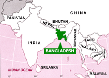
Introduction:
 |
| Bangladesh Map |
Bangladesh is a low-lying country with a total area
of 56,977 square miles or 147,570 square kilometers. It is mostly
surrounded by Indian Territory except for small strip in the southeast
by Myanmar and south by Bay of Bengal.
Most of its
area is relatively flat lying. The only significant uplands are in the
northeast and southeast of the country. Bangladesh has a tropical
monsoon climate marked by sweltering temperatures and high humidity.
The Union
Council is the lowest administrative unit. Each Union comprises about
20,000 inhabitants. Generally 7-10 Union cluster into a Thana (Police
Station). Several Thanas form a District. There are about 560 thanas and
64 districts in Bangladesh.
Bangladesh
has an agrarian economy. Jute and rice are the main cash crops. Other
crops are tea, sugarcane, oilseeds, fruits, spices, vegetables, wheat,
potatoes, tobacco and cotton. The major industries are jute processing,
cotton, garments, steel and pharmaceutical.
 |
| Bangladesh Map With Division |
Basic Information:
Official Name : The People's Republic of Bangladesh
Capital City : Dhaka (Metropolitan area 302.91 sq. Kilometers)
Divisional Headquarters :
1) Dhaka 2) Chittagong 3) Barishal 4) Khulna 5) Rajshahi 6) Sylhet 7) Rangpur
1) Dhaka 2) Chittagong 3) Barishal 4) Khulna 5) Rajshahi 6) Sylhet 7) Rangpur
Districts : 64 (Sixty Four)
Police Stations: 496 (Four Hundred Ninety Six)
City Corporation : 4
Municipally : 119
Union Parishad : 4,472
Standard Time : GMT + 6 hours
Important Industries :
Jute, Sugar, Paper, garments, Fertilizer, Cigarette, Cement, Newsprint, Fishing & Food processing, Leather & Leather goods, Timber, Pharmaceutical Chemical Industry, Ceramic Industries etc.
Jute, Sugar, Paper, garments, Fertilizer, Cigarette, Cement, Newsprint, Fishing & Food processing, Leather & Leather goods, Timber, Pharmaceutical Chemical Industry, Ceramic Industries etc.
Export Items :
Raw jute and products, Tea, Leather and Leather goods, Garments, Frozen Shrimps, Fish products, Newsprint, Paper, Naphtha, Furnish oil, Fertilizer, Computer Software etc.
Raw jute and products, Tea, Leather and Leather goods, Garments, Frozen Shrimps, Fish products, Newsprint, Paper, Naphtha, Furnish oil, Fertilizer, Computer Software etc.
Principal Imports :
Wheat, Oil seeds, Crude Petroleum, Raw Cotton, Edible Oil, Petroleum Products, Fertilizer, Cement, Staple fibers, Yarn, Iron & Steel, Capital goods Raw materials/Chemicals for drugs etc.
Wheat, Oil seeds, Crude Petroleum, Raw Cotton, Edible Oil, Petroleum Products, Fertilizer, Cement, Staple fibers, Yarn, Iron & Steel, Capital goods Raw materials/Chemicals for drugs etc.
Seaports : Chittagong & Mongla.
Inland River ports :
Dhaka, Narayanganj, Chandpur, Barisal, Khulna, Bhairab, Sirajgonj etc.
Dhaka, Narayanganj, Chandpur, Barisal, Khulna, Bhairab, Sirajgonj etc.
Airports :
International : Zia Intl. Airport-Dhaka, Patenga Airport-Chittagong, Osmani Intl. Airport-Sylhet.
International : Zia Intl. Airport-Dhaka, Patenga Airport-Chittagong, Osmani Intl. Airport-Sylhet.
Domestic : Dhaka, Chittagong, Sylhet, Cox's Bazar, Thakurgoan, Syedpur, Rajshahi, Jessoere & Barisal.
Principal Crops :
Rice, Jute, Tea, Tobacco, Wheat, Sugarcane, Vegetables, Potato, Pulses etc.
Rice, Jute, Tea, Tobacco, Wheat, Sugarcane, Vegetables, Potato, Pulses etc.
Rainfall :
1194 mm to 3454 mm (Average during monsoon, June-August)
1194 mm to 3454 mm (Average during monsoon, June-August)
Climactic Variations :
The climate of Bangladesh is tropical monsoon marked by Sweltering temperature and high humidity. Bangladesh has mainly four seasons: summer (March-May), Monsoon (Jun-September), Autumn (Oct-Nov) and Winter (December-February)
The climate of Bangladesh is tropical monsoon marked by Sweltering temperature and high humidity. Bangladesh has mainly four seasons: summer (March-May), Monsoon (Jun-September), Autumn (Oct-Nov) and Winter (December-February)
Rivers :
Padma, Bramhaputra, Jamuna, Meghna, Karnaphuli, Teesta, Arial Khan, Surma etc. (Total 230 rivers including tributaries)
Padma, Bramhaputra, Jamuna, Meghna, Karnaphuli, Teesta, Arial Khan, Surma etc. (Total 230 rivers including tributaries)
Mineral Resources :
Natural Gas, Limestone, Hard rock, Coal lignite, Silica Sand, White clay, Radio-active sand etc. (there is a strong possibilities of oil deposit)
Natural Gas, Limestone, Hard rock, Coal lignite, Silica Sand, White clay, Radio-active sand etc. (there is a strong possibilities of oil deposit)
Satellite Station :
1. Betbunia
2. Talibabad
3. Mohakhali.
1. Betbunia
2. Talibabad
3. Mohakhali.
Radio Stations :
Dhaka, Chittagong, Rajshahi, Rangpur, Khulna, Sylhet, Rangamati, Thakurgaon, Comilla,
Dhaka, Chittagong, Rajshahi, Rangpur, Khulna, Sylhet, Rangamati, Thakurgaon, Comilla,
T.V. Station : Dhaka, Chittagong.
Human Resources :
A substantial manpower reserve well trained and skilled Engineers, Economists, Physicians, Chartered & qualified Accountants, IT Professionals, Technicians, Trained administrative and Managerial Personnel's, abundance of low cost, easily trainable and adoptable and hard Working intelligent and youthful labour force;
Labour rates between 1.5 –3 US$ per day (8-10 hrs.)A substantial manpower reserve well trained and skilled Engineers, Economists, Physicians, Chartered & qualified Accountants, IT Professionals, Technicians, Trained administrative and Managerial Personnel's, abundance of low cost, easily trainable and adoptable and hard Working intelligent and youthful labour force;

No comments:
Post a Comment